


Associated Press science reporter, Seth Borenstein, recently offered his thoughts on two major hurricanes that struck Florida in October. He asserts that climate-change played a prominent role in the devastation.
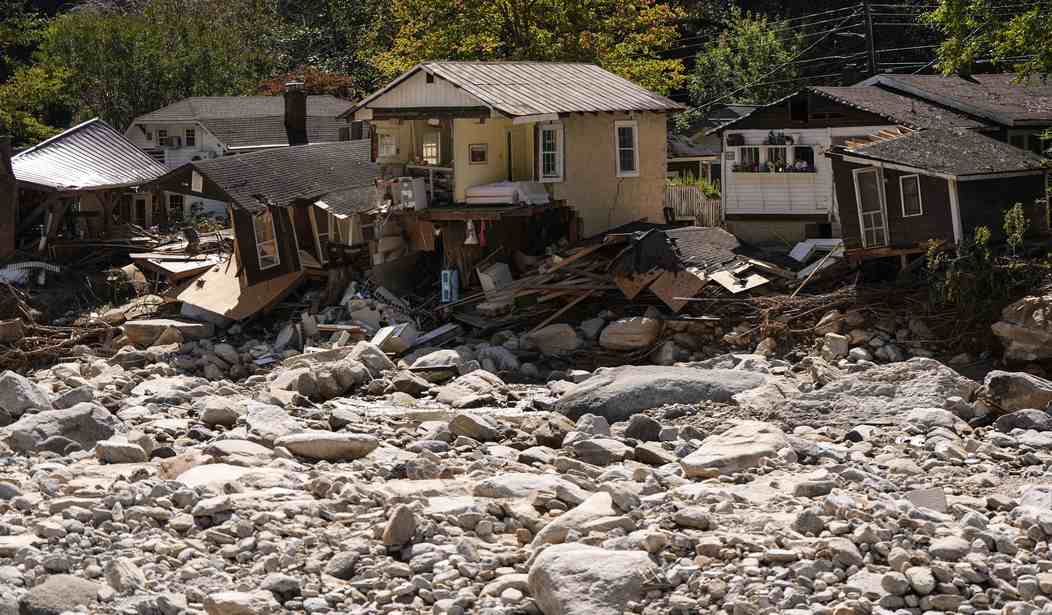
Hurricane Helene made landfall in Florida’s Big Bend then proceeded north into the Carolina mountains. Milton arrived two weeks later, compounding destruction along both Florida coastlines.
Fatalities, mostly resulting from extensive flooding in the Carolina mountains in Helene’s aftermath, rank among the highest from any recent tropical storm.
Yet damage from earlier hurricanes far surpassed modern-day tolls. The Great Galveston Storm (1900) took an estimated 12,000 lives, for example, and ranks as by far the deadliest in the US history. Four more occurred before 1900.
We were forewarned the 2024 hurricane season was to be exceptionally active, as announced in April by the National Hurricane Center.
Mr. Borenstein credits Milton’s "freaky character" to climate change, but seems unaware that the Gulf of Mexico by end of a typical summer harbors more than enough “very warm water” to spawn major hurricanes—if conditions are right. Seasonally warm water is a necessity, but not a sufficient condition for a hurricane's development.
The rapid rate of Milton’s intensification (not unprecedented) and its apparently erratic progress is explained by the patchwork temperature pattern of the surface water that extended from the Yucatan Peninsula, where it began, toward Florida’s Gulf Coast and by the dissecting crosswinds aloft.
Recommended

Hurricane Helene had earlier traveled over the same near-shore waters paralleling the Florida mainland two weeks prior. The earlier storm withdrew substantial energy from the water below and deprived Milton of heat needed to sustain its full strength during final approach. It came ashore as a weakened Category 3 rather than the forecasted Category 4 hurricane.
Both Helene and Milton rank far from being the strongest storms to strike Florida historically. The 1935 Keys Labor Day Hurricane (officially considered the strongest landfalling cyclone in U.S. history) and Hurricanes Andrew and Wilma were much stronger. The 1935 hurricane struck at a full Category 5 (packing 185 mph plus winds) nearly 90 years ago when atmospheric carbon dioxide levels were in the range of 265 ppm compared with 420 ppm today.
Florida boasts a resident population over 23 million. Its coastal properties include among the most extensive and expensive real-estate in the nation and present a far larger target for hurricanes today than in decades past. Accordingly, storm-related casualty losses are greater.
Assertions by the AP reporter that the two 2024 “monster storms” are unlike any of their predecessors seem unpersuasive.
Milton's becoming the 7th major hurricane to make landfall on the U.S. in eight years is un-noteworthy. South Floridians endured four major hurricanes in 2004, each arriving ten days apart, over a six-weeks period. Charlie, Frances, Ivan and Jeanne were followed just a year later by Wilma, a genuine late-season Category 5 coming shore in Florida.
Earlier that same autumn Katrina (2005) had struck New Orleans and the Mississippi Gulf Coast.
What the Associated Press reporter possibly should have said was Milton unexpectedly encountered cooler surface water that abated its peak wind-speeds during final approach.
There is little rhyme or reason for a tropical storm’s precise path and point of landfall, within the advisory “cone” predicted by the National Hurricane Center. The eye of Milton’s exact destination remained uncertain within a few hours before it arrived at Siesta Key.
Quirks remain in understanding the weather realm, but they cannot be properly understood offering climate-change as a convenient explanation.
William D. Balgord, Ph.D. (geochemistry) heads Environmental & Resources Technology, Inc. in Middleton, Wisc.


Join the conversation as a VIP Member